Fil:Bay Bridge collapse.jpg
Det finns ingen version med högre upplösning.
Bay_Bridge_collapse.jpg (341 × 512 pixlar, filstorlek: 21 kbyte, MIME-typ: image/jpeg)
| Denna fil tillhandahålls av Wikimedia Commons. Informationen nedan är kopierad från dess filbeskrivningssida. |
Sammanfattning
| Beskrivning |
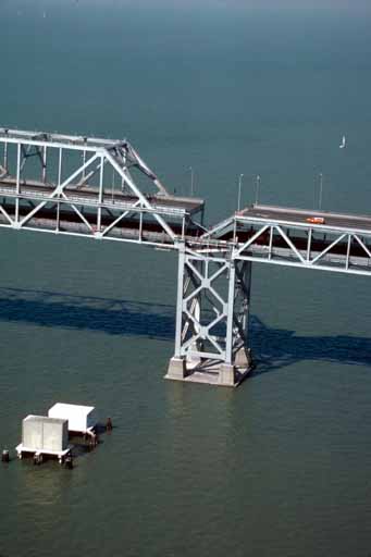
English: Aerial view of roadbed collapse near the interface of the cantilever and truss sections of the San Francisco-Oakland Bay Bridge. View northwestward. Cropped from original version to better fit en:San Francisco–Oakland Bay Bridge article. |
| Datum | Bilden tagen under oktober 1989 |
| Källa |
USGS |
| Skapare | C.E. Meyer |
| Tillstånd (Återanvändning av denna fil) |
PD-USGOV-INTERIOR-USGS. |
| Andra versioner |
|


Licensiering
This image is in the public domain in the United States because it only contains materials that originally came from the United States Geological Survey, an agency of the United States Department of the Interior. For more information, see the official USGS copyright policy.
|
Filhistorik
Klicka på ett datum/klockslag för att se filen som den såg ut då.
| Datum/Tid | Miniatyrbild | Dimensioner | Användare | Kommentar | |
|---|---|---|---|---|---|
| nuvarande | 21 september 2005 kl. 23.17 | | 341 × 512 (21 kbyte) | Wolfgang K | [http://wrgis.wr.usgs.gov/dds/dds-29/ USGS photo] from 1989 Loma Prieta earthquake. '''Caption''': Aerial view of roadbed collapse near the interface of the cantil�T truss sections of the San Francisco-Oakland Bay Bridge. View northwestward. [C. |
Filanvändning
Följande 2 sidor använder den här filen:
Global filanvändning
Följande andra wikier använder denna fil:
- Användande på af.wikipedia.org
- Användande på ar.wikipedia.org
- Användande på de.wikipedia.org
- Användande på en.wikipedia.org
- Användande på fr.wikipedia.org
- Användande på it.wikipedia.org
- Användande på ja.wikipedia.org
- Användande på sco.wikipedia.org
- Användande på vi.wikipedia.org
- Användande på zh.wikipedia.org