Fil:Andaman nicobar 76.jpg

Storlek på förhandsvisningen: 259 × 599 pixlar. Andra upplösningar: 103 × 240 pixlar | 207 × 480 pixlar | 894 × 2 068 pixlar.
Originalfil (894 × 2 068 pixlar, filstorlek: 315 kbyte, MIME-typ: image/jpeg)
| Denna fil tillhandahålls av Wikimedia Commons. Informationen nedan är kopierad från dess filbeskrivningssida. |
Sammanfattning
| Beskrivning |
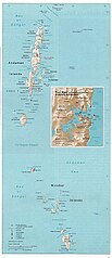
English: Map of the Nicobar and Andaman Islands. |
| Datum | |
| Källa | Courtesy of the University of Texas Libraries, The University of Texas at Austin. Reproduced from the Perry-Castañeda Library Map Collection of the University of Texas, Austin; originally from The Indian Ocean Atlas, produced and published (1976) by the U.S. Central Intelligence Agency. |
| Skapare | Pyramide~commonswiki |
| Tillstånd (Återanvändning av denna fil) |
This material is in the public domain according to notes at Indian Ocean Maps and The UT Library Web Material Usage Statement |

|
Det finns en vektorversion av denna rasterbild (SVG).
När vektorbilden är lämpligare ska den användas istället för rasterbilden. File:Andaman nicobar 76.jpg → File:Map of Nicobar and Andaman Islands-en.svg
För mer information om vektorgrafik, se artikeln Commons transition to SVG (på engelska). |
 |
Licensiering
| This image is a work of a Central Intelligence Agency employee, taken or made as part of that person's official duties. As a Work of the United States Government, this image or media is in the public domain in the United States.
|

|
Filhistorik
Klicka på ett datum/klockslag för att se filen som den såg ut då.
| Datum/Tid | Miniatyrbild | Dimensioner | Användare | Kommentar | |
|---|---|---|---|---|---|
| nuvarande | 26 december 2004 kl. 23.00 | | 894 × 2 068 (315 kbyte) | Pyramide~commonswiki | Taken from that map site of Texas University and it says that CIA made it. It qualifies to teh rules stated at http://www.lib.utexas.edu/usage_statement.html |
Filanvändning
Inga sidor använder den här filen.
Global filanvändning
Följande andra wikier använder denna fil:
- Användande på ar.wikipedia.org
- Användande på ast.wikipedia.org
- Användande på bcl.wikipedia.org
- Användande på bg.wikipedia.org
- Användande på bn.wikipedia.org
- Användande på bn.wikiquote.org
- Användande på ca.wikipedia.org
- Användande på da.wikipedia.org
- Användande på de.wikipedia.org
- Användande på de.wikivoyage.org
- Användande på en.wikipedia.org
- Användande på eo.wikipedia.org
- Användande på es.wikipedia.org
- Användande på eu.wikipedia.org
- Användande på fa.wikipedia.org
- Användande på fi.wikipedia.org
- Användande på fr.wikipedia.org
- Användande på ga.wikipedia.org
- Användande på hif.wikipedia.org
- Användande på hu.wikipedia.org
- Användande på id.wikipedia.org
- Användande på incubator.wikimedia.org
- Användande på ja.wikipedia.org
- Användande på jv.wikipedia.org
- Användande på kk.wikipedia.org
- Användande på kn.wikipedia.org
- Användande på ko.wikipedia.org
- Användande på la.wikipedia.org
- Användande på lt.wikipedia.org
- Användande på mk.wikipedia.org
- Användande på ml.wikipedia.org
Visa mer globalt användande av denna fil.