Fil:Aerial-View-Minamitori-Island-1987.jpg

Storlek på förhandsvisningen: 800 × 507 pixlar. Andra upplösningar: 320 × 203 pixlar | 640 × 405 pixlar | 1 024 × 649 pixlar | 1 280 × 811 pixlar | 2 824 × 1 789 pixlar.
Originalfil (2 824 × 1 789 pixlar, filstorlek: 1,09 Mbyte, MIME-typ: image/jpeg)
| Denna fil tillhandahålls av Wikimedia Commons. Informationen nedan är kopierad från dess filbeskrivningssida. |
Sammanfattning
| Beskrivning |
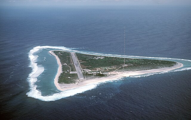
English: Aerial view of Minamitori Island (Minami-Torishima), Japan. There is a runway which supported the US Coast Guard station located there prior to 1993. Minamitori Island is the easternmost island of the Japanese archipelago.
Deutsch: Luftaufnahme der Minamitori Insel (Minami-Torishima), Japan.
日本語: 南鳥島の空中写真。 |
|||
| Datum | ||||
| Källa |
|
|||
| Skapare | Chief Master Sergeant Don Sutherland, U.S. Air Force |
Licensiering
This image is a work of a U.S. military or Department of Defense employee, taken or made as part of that person's official duties. As a work of the U.S. federal government, the image is in the public domain in the United States.
|
 |
Filhistorik
Klicka på ett datum/klockslag för att se filen som den såg ut då.
| Datum/Tid | Miniatyrbild | Dimensioner | Användare | Kommentar | |
|---|---|---|---|---|---|
| nuvarande | 18 januari 2007 kl. 03.38 | | 2 824 × 1 789 (1,09 Mbyte) | Balcer~commonswiki | ID: DFST8708298 Service Depicted: Coalition or Allied Forces Aerial view of Marcus Island and the runway which supports the US Coast Guard station located there. Marcus Island is the southernmost island in the Japanese chain. Camera Operator: CMSGT |
Filanvändning
Följande sida använder den här filen:
Global filanvändning
Följande andra wikier använder denna fil:
- Användande på ar.wikipedia.org
- Användande på ast.wikipedia.org
- Användande på az.wikipedia.org
- Användande på be.wikipedia.org
- Användande på ca.wikipedia.org
- Användande på ceb.wikipedia.org
- Användande på cs.wikipedia.org
- Användande på de.wikipedia.org
- Användande på el.wikipedia.org
- Användande på en.wikipedia.org
- Användande på es.wikipedia.org
- Användande på et.wikipedia.org
- Användande på eu.wikipedia.org
- Användande på fa.wikipedia.org
- Användande på fi.wikipedia.org
- Användande på frr.wikipedia.org
- Användande på fr.wikipedia.org
- Användande på fr.wiktionary.org
- Användande på gl.wikipedia.org
- Användande på hy.wikipedia.org
- Användande på it.wikipedia.org
- Användande på ja.wikipedia.org
Visa mer globalt användande av denna fil.