Fil:1952 Electoral Map.png

Storlek på förhandsvisningen: 800 × 430 pixlar. Andra upplösningar: 320 × 172 pixlar | 640 × 344 pixlar | 1 182 × 635 pixlar.
Originalfil (1 182 × 635 pixlar, filstorlek: 158 kbyte, MIME-typ: image/png)
| Denna fil tillhandahålls av Wikimedia Commons. Informationen nedan är kopierad från dess filbeskrivningssida. |
| U.S. presidential election maps from the National Atlas of the United States |
| See also: SVG maps |
| 1789 · 1792 · 1796 · 1800 · 1804 · 1808 · 1812 · 1816 · 1820 · 1824 · 1828 · 1832 · 1836 · 1840 · 1844 · 1848 · 1852 · 1856 · 1860 · 1864 · 1868 · 1872 · 1876 · 1880 · 1884 · 1888 · 1892 · 1896 · 1900 · 1904 · 1908 · 1912 · 1916 · 1920 · 1924 · 1928 · 1932 · 1936 · 1940 · 1944 · 1948 · 1952 · 1956 · 1960 · 1964 · 1968 · 1972 · 1976 · 1980 · 1984 · 1988 · 1992 · 1996 · 2000 · 2004 |
Sammanfattning
| Beskrivning |
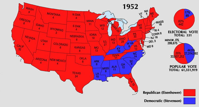
English: 1952 Electoral College Map |
| Källa | https://nationalmap.gov/small_scale/printable/elections.html |
| Skapare | United States Geological Survey |
Licensiering
This map was obtained from an edition of the National Atlas of the United States. Like almost all works of the U.S. federal government, works from the National Atlas are in the public domain in the United States.
Online access: NationalAtlas.gov | 1970 print edition: Library of Congress, Perry-Castañeda Library
|
Filhistorik
Klicka på ett datum/klockslag för att se filen som den såg ut då.
| Datum/Tid | Miniatyrbild | Dimensioner | Användare | Kommentar | |
|---|---|---|---|---|---|
| nuvarande | 26 juni 2008 kl. 00.19 | | 1 182 × 635 (158 kbyte) | Tallicfan20 | |
| 25 juni 2008 kl. 23.50 |  | 1 182 × 635 (158 kbyte) | Tallicfan20 | better coloring | |
| 25 maj 2008 kl. 04.39 |  | 1 182 × 635 (150 kbyte) | Tallicfan20 | ||
| 16 maj 2008 kl. 20.15 |  | 1 182 × 635 (97 kbyte) | Tallicfan20 | {{Information |Description=1952 Electoral College Map |Source=National Atlas |Date=5/16/2008 |Author=National Atlas |Permission=PD |other_versions= }} {{PD-USGov-Atlas}} |
Filanvändning
Följande sida använder den här filen:
Global filanvändning
Följande andra wikier använder denna fil:
- Användande på en.wikipedia.org
- Användande på fi.wikipedia.org
- Användande på uk.wikipedia.org